

 Field service companies today are using cloud software and iPads to improve work-order management. Airline pilots are using iPads in the cockpit. And even thermostats are becoming sleek examples of 21st-century technology. Now, a new iPad app shows that even utility districts and municipalities are getting in on the mobile-tech action.
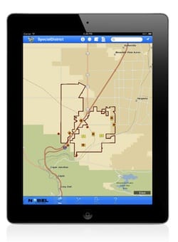
A new tool from Nobel Systems called the GeoViewer Mobile for iPad aims to help field crews and their managers use Geographic Information Systems (GIS) data to access and interact with a virtual library of information, including aerial maps, schematics, renderings, reports, service history, and anything else a field worker could need. It’s being billed as a modern, user-friendly approach to an industry sorely in need of one.
This app also follows a trend we’ve been noticing: city governments and municipalities adopting mobile technologies to streamline their field operations. As we reported earlier this year, Boston’s public works department is using a mobile app to detect and more quickly report potholes throughout the city. We also ran a story detailing how the police department in Redlands, Calif. is using GIS and mobile computing to analyze crime. This app from Nobel System, which of course is also targeted for use by city governments, appears to be the latest in what may no longer be considered a trend. We’re eager to see what’s next.
More: How Mobile Apps Are Reinventing Citizen Field Service for Boston.
Click here to download a free whitepaper, “Five Steps to Make Field Service Profitable.”

No need to hire expensive programmers to create iOS, Android and HTML5 apps. I am using Snappii mobile app development enterprise which doesn’t require programming skills and have already made several feature-rich apps. You can try it yourself. Connect your web services to mobile apps with Snappii.
Knowledgeable mobile app development firm delivers a huge variety of solutions. Some samples of services it can deliver include expert development talents in BlackBerry, Android, iphone, J2ME, Palm, Symbian and lots of more.here You provide some nice example of this which is very incredible.